


coutances 2

lionelnottat
Gebruiker
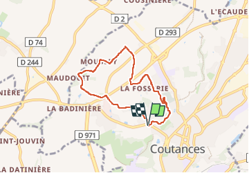

Lengte
6,1 km

Max. hoogte
126 m

Positief hoogteverschil
116 m
Km-Effort
7,6 km

Min. hoogte
39 m

Negatief hoogteverschil
114 m
Boucle
Ja
Datum van aanmaak :
2024-08-22 13:21:28.389
Laatste wijziging :
2024-08-22 15:28:54.452
1h41
Moeilijkheid : Medium

Gratisgps-wandelapplicatie
 SityTrail
IGN / Geografische instituten
SityTrail Plus
De wereld gaat voor u open
Over ons
Tocht Stappen van 6,1 km beschikbaar op Normandië, Manche, Coutances. Deze tocht wordt voorgesteld door lionelnottat.
Plaatsbepaling
Land:
France
Regio :
Normandië
Departement/Provincie :
Manche
Gemeente :
Coutances
Locatie:
Unknown
Vertrek:(Dec)
Vertrek:(UTM)
613050 ; 5434342 (30U) N.
Opmerkingen