


GR 400 le Falgoux le Fau

taguette
Gebruiker
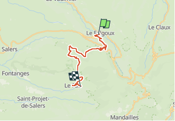

Lengte
20 km

Max. hoogte
1576 m

Positief hoogteverschil
956 m
Km-Effort
33 km

Min. hoogte
888 m

Negatief hoogteverschil
894 m
Boucle
Neen
Datum van aanmaak :
2024-08-27 05:36:22.857
Laatste wijziging :
2024-08-27 14:56:10.569
7h58
Moeilijkheid : Zeer moeilijk

Gratisgps-wandelapplicatie
 SityTrail
IGN / Geografische instituten
SityTrail Plus
De wereld gaat voor u open
Over ons
Tocht Stappen van 20 km beschikbaar op Auvergne-Rhône-Alpes, Cantal, Le Falgoux. Deze tocht wordt voorgesteld door taguette.
Plaatsbepaling
Land:
France
Regio :
Auvergne-Rhône-Alpes
Departement/Provincie :
Cantal
Gemeente :
Le Falgoux
Locatie:
Unknown
Vertrek:(Dec)
Vertrek:(UTM)
470140 ; 5000044 (31T) N.
Opmerkingen