


2024-09-09_11h35m58_Autour du Mt Aigoual

gadafo
Gebruiker
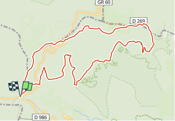

Lengte
13,3 km

Max. hoogte
1557 m

Positief hoogteverschil
458 m
Km-Effort
19,4 km

Min. hoogte
1293 m

Negatief hoogteverschil
458 m
Boucle
Ja
Datum van aanmaak :
2024-09-09 09:35:58.277
Laatste wijziging :
2024-09-09 15:20:32.888
4h25
Moeilijkheid : Zeer moeilijk

Gratisgps-wandelapplicatie
 SityTrail
IGN / Geografische instituten
SityTrail Plus
De wereld gaat voor u open
Over ons
Tocht Stappen van 13,3 km beschikbaar op Occitanië, Gard, Val-d'Aigoual. Deze tocht wordt voorgesteld door gadafo.
Plaatsbepaling
Land:
France
Regio :
Occitanië
Departement/Provincie :
Gard
Gemeente :
Val-d'Aigoual
Locatie:
Valleraugue
Vertrek:(Dec)
Vertrek:(UTM)
543305 ; 4883459 (31T) N.
Opmerkingen