


laboule Loubaresse

Clo0413
Gebruiker
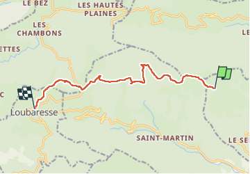

Lengte
11,1 km

Max. hoogte
1458 m

Positief hoogteverschil
268 m
Km-Effort
15,2 km

Min. hoogte
1218 m

Negatief hoogteverschil
426 m
Boucle
Neen
Datum van aanmaak :
2024-09-09 09:56:45.432
Laatste wijziging :
2024-09-09 14:41:37.147
3h08
Moeilijkheid : Moeilijk

Gratisgps-wandelapplicatie
 SityTrail
IGN / Geografische instituten
SityTrail Plus
De wereld gaat voor u open
Over ons
Tocht Stappen van 11,1 km beschikbaar op Auvergne-Rhône-Alpes, Ardèche, Laboule. Deze tocht wordt voorgesteld door Clo0413.
Plaatsbepaling
Land:
France
Regio :
Auvergne-Rhône-Alpes
Departement/Provincie :
Ardèche
Gemeente :
Laboule
Locatie:
Unknown
Vertrek:(Dec)
Vertrek:(UTM)
590431 ; 4940029 (31T) N.
Opmerkingen