


Col des Marchands

aldaus
Gebruiker

Lengte
14,1 km

Max. hoogte
1012 m

Positief hoogteverschil
672 m
Km-Effort
23 km

Min. hoogte
473 m

Negatief hoogteverschil
675 m
Boucle
Ja
Datum van aanmaak :
2024-09-15 08:30:38.679
Laatste wijziging :
2024-10-01 11:18:30.811
5h14
Moeilijkheid : Zeer moeilijk

Gratisgps-wandelapplicatie
 SityTrail
IGN / Geografische instituten
SityTrail Plus
De wereld gaat voor u open
Over ons
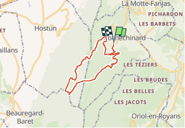
Tocht Stappen van 14,1 km beschikbaar op Auvergne-Rhône-Alpes, Drôme, Rochechinard. Deze tocht wordt voorgesteld door aldaus.
Plaatsbepaling
Land:
France
Regio :
Auvergne-Rhône-Alpes
Departement/Provincie :
Drôme
Gemeente :
Rochechinard
Locatie:
Unknown
Vertrek:(Dec)
Vertrek:(UTM)
676898 ; 4988878 (31T) N.
Opmerkingen