


Les Vignes

fanthou
Gebruiker

Lengte
9,9 km

Max. hoogte
305 m

Positief hoogteverschil
120 m
Km-Effort
11,5 km

Min. hoogte
234 m

Negatief hoogteverschil
122 m
Boucle
Ja
Datum van aanmaak :
2024-09-16 15:56:53.446
Laatste wijziging :
2024-09-16 15:57:19.291
2h36
Moeilijkheid : Medium

Gratisgps-wandelapplicatie
 SityTrail
IGN / Geografische instituten
SityTrail Plus
De wereld gaat voor u open
Over ons
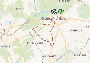
Tocht Stappen van 9,9 km beschikbaar op Centre-Val de Loire, Cher, Châteaumeillant. Deze tocht wordt voorgesteld door fanthou.
Plaatsbepaling
Land:
France
Regio :
Centre-Val de Loire
Departement/Provincie :
Cher
Gemeente :
Châteaumeillant
Locatie:
Unknown
Vertrek:(Dec)
Vertrek:(UTM)
438838 ; 5156794 (31T) N.
Opmerkingen