


20240916 Lecce

Childebert
Gebruiker

Lengte
162 km

Max. hoogte
181 m

Positief hoogteverschil
1204 m
Km-Effort
178 km

Min. hoogte
-2 m

Negatief hoogteverschil
1204 m
Boucle
Ja
Datum van aanmaak :
2024-09-16 06:46:32.748
Laatste wijziging :
2024-09-16 16:29:02.222
9h40
Moeilijkheid : Gemakkelijk

Gratisgps-wandelapplicatie
 SityTrail
IGN / Geografische instituten
SityTrail Plus
De wereld gaat voor u open
Over ons
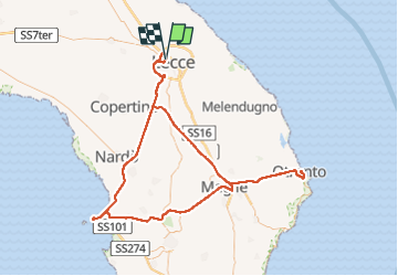
Tocht Auto van 162 km beschikbaar op Apulië, Lecce, Lecce. Deze tocht wordt voorgesteld door Childebert.
Plaatsbepaling
Land:
Italy
Regio :
Apulië
Departement/Provincie :
Lecce
Gemeente :
Lecce
Locatie:
Unknown
Vertrek:(Dec)
Vertrek:(UTM)
258607 ; 4471801 (34T) N.
Opmerkingen