Tocht Stappen Marcillac-la-Croisille - Marcillac la Cille bord du lac  du  pont  de  Malezr au Puy Nachet - Photo

Marcillac la Cille bord du lac du pont de Malezr au Puy Nachet

 grageot
grageot

Gebruiker

© OpenStreetMap contributors
Lengte
Lengte
11,3 km
Max. hoogte
Max. hoogte
596 m
Positief hoogteverschil
226 m
Km-Effort
Km-Effort  
14,3 km
Min. hoogte
Min. hoogte
488 m
Negatief hoogteverschil
227 m
Boucle
Boucle
Ja
Datum van aanmaak :
2015-05-11 00:00:00.0
Laatste wijziging :
2015-05-11 00:00:00.0

(0 Bericht)

Stappen
Stappen
3h01
Moeilijkheid : Gemakkelijk

Scan deze QR-code om de tocht te openen in de SityTrail-applicatie

Gratisgps-wandelapplicatie

Logo SityTrail SityTrail

IGN / Geografische instituten

SityTrail uit de App Store downloaden SityTrail uit Google Play downloaden

Logo SityTrail SityTrail World

De wereld gaat voor u open

SityTrail uit de App Store downloaden SityTrail uit Google Play downloaden SityTrail op Huawei AppGallery downloaden

Over ons

Tocht Stappen van 11,3 km beschikbaar op Nieuw-Aquitanië, Corrèze, Marcillac-la-Croisille. Deze tocht wordt voorgesteld door grageot.

Beschrijving

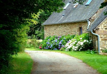
belle rando en sous bois et sur les chemins de pêcheurs.
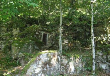
Au pont de Malèze, je pensais trouver un sentier de pêcheurs mais il n'existe pas, la pente est trop raide  et je suis remonté au hameau de Lafont.
Pour le reste aucun problème les sentiers sont bien visibles

Hoogteprofiel

Plaatsbepaling

Land:
France
Regio :
Nieuw-Aquitanië
Departement/Provincie :
Corrèze
Gemeente :
Marcillac-la-Croisille
Locatie:
Unknown
Vertrek:(Dec)
Vertrek:(UTM)
424335 ; 5014142 (31T) N.

Wandeltochten in de omgeving

Tocht Stappen Lafage-sur-Sombre - Bois et moulins - Lafage sur Sombre - Pays d'Egletons  - Photo
Stappen
tracegps

Stappen

Medium
(1)
Lafage-sur-Sombre, Nieuw-Aquitanië, Corrèze, France
6,9 km | 8,7 km-effort
2h 0min
Ja
Tocht Te voet Le Jardin - Sur les chemins de Marcouyeux - Photo
Te voet
PRO

Te voet

Gemakkelijk
Le Jardin, Nieuw-Aquitanië, Corrèze, France
6,5 km | 8,1 km-effort
1h 50min
Ja
Tocht Te voet Le Jardin - Le Jardin Bourg - Photo
Te voet
PRO

Te voet

Gemakkelijk
Le Jardin, Nieuw-Aquitanië, Corrèze, France
4,4 km | 5,5 km-effort
1h 15min
Ja
Tocht Paard Lafage-sur-Sombre - Sur les traces du Tacot - Lafage sur Sombre - Pays d'Egletons  - Photo
Paard
tracegps

Paard

Medium
Lafage-sur-Sombre, Nieuw-Aquitanië, Corrèze, France
7,9 km | 9,6 km-effort
1h 10min
Ja
Tocht Mountainbike Lafage-sur-Sombre - Sur les traces du Tacot - Lafage sur Sombre - Pays d'Egletons  - Photo
Mountainbike
tracegps

Mountainbike

Medium
Lafage-sur-Sombre, Nieuw-Aquitanië, Corrèze, France
7,9 km | 9,6 km-effort
40min
Ja
Tocht Stappen Lafage-sur-Sombre - Sur les traces du Tacot - Lafage sur Sombre - Pays d'Egletons  - Photo
Stappen
tracegps

Stappen

Medium
Lafage-sur-Sombre, Nieuw-Aquitanië, Corrèze, France
7,9 km | 9,6 km-effort
3h 0min
Ja
Tocht Mountainbike Lafage-sur-Sombre - Bois et moulins - Lafage sur Sombre - Pays d'Egletons  - Photo
Mountainbike
tracegps

Mountainbike

Medium
Lafage-sur-Sombre, Nieuw-Aquitanië, Corrèze, France
6,9 km | 8,7 km-effort
30min
Ja
Tocht Paard Le Jardin - Sur les chemins de Marcouyeux - Le Jardin - Pays d'Egletons  - Photo
Paard
tracegps

Paard

Medium
Le Jardin, Nieuw-Aquitanië, Corrèze, France
6,4 km | 8 km-effort
1h 10min
Ja
Tocht Mountainbike Le Jardin - Sur les chemins de Marcouyeux - Le Jardin - Pays d'Egletons  - Photo
Mountainbike
tracegps

Mountainbike

Medium
Le Jardin, Nieuw-Aquitanië, Corrèze, France
6,4 km | 8 km-effort
34min
Ja


Sluiten
Mijn abonnementen