


Trace M1 M2 Lamayou Guy

mitch1952
Gebruiker
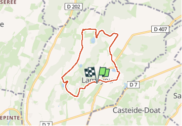

Lengte
6,9 km

Max. hoogte
338 m

Positief hoogteverschil
102 m
Km-Effort
8,2 km

Min. hoogte
259 m

Negatief hoogteverschil
103 m
Boucle
Ja
Datum van aanmaak :
2024-09-25 12:14:11.0
Laatste wijziging :
2024-09-25 14:11:44.801

Gratisgps-wandelapplicatie
 SityTrail
IGN / Geografische instituten
SityTrail Plus
De wereld gaat voor u open
Over ons
Tocht van 6,9 km beschikbaar op Nieuw-Aquitanië, Pyrénées-Atlantiques, Lamayou. Deze tocht wordt voorgesteld door mitch1952.
Plaatsbepaling
Land:
France
Regio :
Nieuw-Aquitanië
Departement/Provincie :
Pyrénées-Atlantiques
Gemeente :
Lamayou
Locatie:
Unknown
Vertrek:(Dec)
Vertrek:(UTM)
740738 ; 4807408 (30T) N.
Opmerkingen