


(J12)-Gîte du Volcan - Basse Vallée (Gite Theophane & Yolaine)

GeorgesV.
Gebruiker
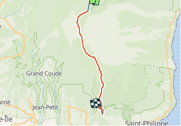

Lengte
21 km

Max. hoogte
2352 m

Positief hoogteverschil
209 m
Km-Effort
30 km

Min. hoogte
459 m

Negatief hoogteverschil
1990 m
Boucle
Neen
Datum van aanmaak :
2024-10-01 03:05:44.0
Laatste wijziging :
2024-10-01 12:33:35.784

Gratisgps-wandelapplicatie
 SityTrail
IGN / Geografische instituten
SityTrail Plus
De wereld gaat voor u open
Over ons
Tocht van 21 km beschikbaar op Réunion, Onbekend, Sainte-Rose. Deze tocht wordt voorgesteld door GeorgesV..
Plaatsbepaling
Land:
France
Regio :
Réunion
Departement/Provincie :
Onbekend
Gemeente :
Sainte-Rose
Locatie:
Unknown
Vertrek:(Dec)
Vertrek:(UTM)
363761 ; 7653222 (40K) Z.
Opmerkingen