


Via Columbani 15 du 10.10.2024

bene_dictus77
Gebruiker
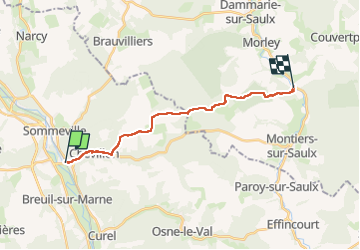

Lengte
15,6 km

Max. hoogte
352 m

Positief hoogteverschil
284 m
Km-Effort
19,1 km

Min. hoogte
169 m

Negatief hoogteverschil
186 m
Boucle
Neen
Datum van aanmaak :
2024-10-10 07:50:41.181
Laatste wijziging :
2024-10-10 12:32:34.051
4h38
Moeilijkheid : Heel gemakkelijk

Gratisgps-wandelapplicatie
 SityTrail
IGN / Geografische instituten
SityTrail Plus
De wereld gaat voor u open
Over ons
Tocht Stappen van 15,6 km beschikbaar op Grand Est, Haute-Marne, Chevillon. Deze tocht wordt voorgesteld door bene_dictus77.
Beschrijving
de Chevillon à ancienne abbaye d'Ecurey
Plaatsbepaling
Land:
France
Regio :
Grand Est
Departement/Provincie :
Haute-Marne
Gemeente :
Chevillon
Locatie:
Unknown
Vertrek:(Dec)
Vertrek:(UTM)
655933 ; 5376693 (31U) N.
Opmerkingen