


montagne d uzes

rando30129
Gebruiker
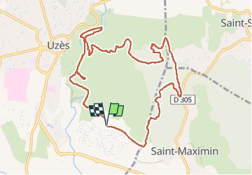

Lengte
12 km

Max. hoogte
184 m

Positief hoogteverschil
214 m
Km-Effort
14,8 km

Min. hoogte
69 m

Negatief hoogteverschil
211 m
Boucle
Ja
Datum van aanmaak :
2024-10-11 11:39:18.907
Laatste wijziging :
2024-10-11 15:17:43.53
3h37
Moeilijkheid : Medium

Gratisgps-wandelapplicatie
 SityTrail
IGN / Geografische instituten
SityTrail Plus
De wereld gaat voor u open
Over ons
Tocht Stappen van 12 km beschikbaar op Occitanië, Gard, Uzès. Deze tocht wordt voorgesteld door rando30129.
Beschrijving
montagne d uzes
Plaatsbepaling
Land:
France
Regio :
Occitanië
Departement/Provincie :
Gard
Gemeente :
Uzès
Locatie:
Unknown
Vertrek:(Dec)
Vertrek:(UTM)
614777 ; 4872631 (31T) N.
Opmerkingen