


26 Chaudière, Bougeon, col Bauras 12.5Kms 515m

DEYGAT
Gebruiker
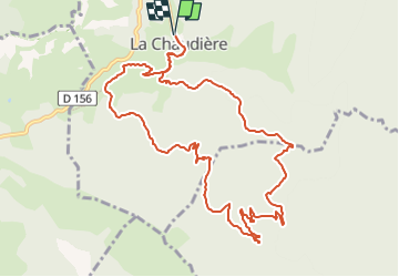

Lengte
12,4 km

Max. hoogte
1150 m

Positief hoogteverschil
513 m
Km-Effort
19,2 km

Min. hoogte
827 m

Negatief hoogteverschil
513 m
Boucle
Ja
Datum van aanmaak :
2024-10-13 08:21:15.262
Laatste wijziging :
2024-10-13 08:21:15.262

Gratisgps-wandelapplicatie
 SityTrail
IGN / Geografische instituten
SityTrail Plus
De wereld gaat voor u open
Over ons
Tocht van 12,4 km beschikbaar op Auvergne-Rhône-Alpes, Drôme, La Chaudière. Deze tocht wordt voorgesteld door DEYGAT.
Plaatsbepaling
Land:
France
Regio :
Auvergne-Rhône-Alpes
Departement/Provincie :
Drôme
Gemeente :
La Chaudière
Locatie:
Unknown
Vertrek:(Dec)
Vertrek:(UTM)
675709 ; 4944585 (31T) N.
Opmerkingen