


Etoile mix

ophness
Gebruiker
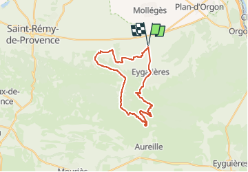

Lengte
27 km

Max. hoogte
321 m

Positief hoogteverschil
463 m
Km-Effort
33 km

Min. hoogte
61 m

Negatief hoogteverschil
463 m
Boucle
Ja
Datum van aanmaak :
2024-11-02 18:36:39.0
Laatste wijziging :
2024-11-02 18:36:41.661

Gratisgps-wandelapplicatie
 SityTrail
IGN / Geografische instituten
SityTrail Plus
De wereld gaat voor u open
Over ons
Tocht van 27 km beschikbaar op Provence-Alpes-Côte d'Azur, Bouches-du-Rhône, Eygalières. Deze tocht wordt voorgesteld door ophness.
Plaatsbepaling
Land:
France
Regio :
Provence-Alpes-Côte d'Azur
Departement/Provincie :
Bouches-du-Rhône
Gemeente :
Eygalières
Locatie:
Unknown
Vertrek:(Dec)
Vertrek:(UTM)
656704 ; 4849323 (31T) N.
Opmerkingen