


Duranus - col de l’Autaret

Arnaud Stévenard
Gebruiker
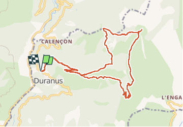

Lengte
13,2 km

Max. hoogte
1273 m

Positief hoogteverschil
819 m
Km-Effort
24 km

Min. hoogte
493 m

Negatief hoogteverschil
819 m
Boucle
Ja
Datum van aanmaak :
2024-11-03 07:38:26.0
Laatste wijziging :
2024-11-03 14:00:18.358
6h19
Moeilijkheid : Gemakkelijk

Gratisgps-wandelapplicatie
 SityTrail
IGN / Geografische instituten
SityTrail Plus
De wereld gaat voor u open
Over ons
Tocht Stappen van 13,2 km beschikbaar op Provence-Alpes-Côte d'Azur, Alpes-Maritimes, Duranus. Deze tocht wordt voorgesteld door Arnaud Stévenard.
Plaatsbepaling
Land:
France
Regio :
Provence-Alpes-Côte d'Azur
Departement/Provincie :
Alpes-Maritimes
Gemeente :
Duranus
Locatie:
Unknown
Vertrek:(Dec)
Vertrek:(UTM)
359970 ; 4861790 (32T) N.
Opmerkingen