


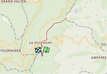
Vosges: Le Tanet depuis refuge 3 fours

MathieuBourgois
Gebruiker

Lengte
10,1 km

Max. hoogte
1281 m

Positief hoogteverschil
382 m
Km-Effort
15,2 km

Min. hoogte
1141 m

Negatief hoogteverschil
381 m
Boucle
Ja
Datum van aanmaak :
2024-11-04 20:11:40.36
Laatste wijziging :
2024-11-04 20:14:30.136
5h50
Moeilijkheid : Medium

Gratisgps-wandelapplicatie
 SityTrail
IGN / Geografische instituten
SityTrail Plus
De wereld gaat voor u open
Over ons
Tocht Sneeuwschoenen van 10,1 km beschikbaar op Grand Est, Haut-Rhin, Stosswihr. Deze tocht wordt voorgesteld door MathieuBourgois.
Plaatsbepaling
Land:
France
Regio :
Grand Est
Departement/Provincie :
Haut-Rhin
Gemeente :
Stosswihr
Locatie:
Unknown
Vertrek:(Dec)
Vertrek:(UTM)
352803 ; 5324131 (32U) N.
Opmerkingen