


Bus St Rémi

Fky78
Gebruiker
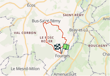

Lengte
8,4 km

Max. hoogte
141 m

Positief hoogteverschil
144 m
Km-Effort
10,3 km

Min. hoogte
36 m

Negatief hoogteverschil
144 m
Boucle
Ja
Datum van aanmaak :
2024-11-09 10:23:52.499
Laatste wijziging :
2024-11-09 10:34:08.523
2h20
Moeilijkheid : Gemakkelijk

Gratisgps-wandelapplicatie
 SityTrail
IGN / Geografische instituten
SityTrail Plus
De wereld gaat voor u open
Over ons
Tocht Te voet van 8,4 km beschikbaar op Normandië, Eure, Vexin-sur-Epte. Deze tocht wordt voorgesteld door Fky78.
Plaatsbepaling
Land:
France
Regio :
Normandië
Departement/Provincie :
Eure
Gemeente :
Vexin-sur-Epte
Locatie:
Unknown
Vertrek:(Dec)
Vertrek:(UTM)
400754 ; 5441929 (31U) N.
Opmerkingen