


Fouqueux

Rando MLC
Gebruiker
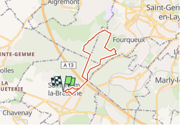

Lengte
11,1 km

Max. hoogte
198 m

Positief hoogteverschil
195 m
Km-Effort
13,7 km

Min. hoogte
109 m

Negatief hoogteverschil
195 m
Boucle
Ja
Datum van aanmaak :
2024-11-12 16:39:28.608
Laatste wijziging :
2025-01-02 14:39:40.141
3h07
Moeilijkheid : Gemakkelijk

Gratisgps-wandelapplicatie
 SityTrail
IGN / Geografische instituten
SityTrail Plus
De wereld gaat voor u open
Over ons
Tocht Te voet van 11,1 km beschikbaar op Île-de-France, Yvelines, Saint-Nom-la-Bretèche. Deze tocht wordt voorgesteld door Rando MLC.
Plaatsbepaling
Land:
France
Regio :
Île-de-France
Departement/Provincie :
Yvelines
Gemeente :
Saint-Nom-la-Bretèche
Locatie:
Unknown
Vertrek:(Dec)
Vertrek:(UTM)
428096 ; 5412666 (31U) N.
Opmerkingen