


Couesmes Château-la-Vallière la Gare - PR GRP Castelvalérie Marcilly Braye Villiers - 27km 280m 6h05 (40mn) - 2024 11 13

Orcal37
Gebruiker GUIDE
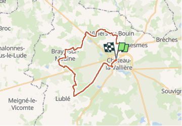

Lengte
27 km

Max. hoogte
121 m

Positief hoogteverschil
278 m
Km-Effort
31 km

Min. hoogte
54 m

Negatief hoogteverschil
278 m
Boucle
Ja
Datum van aanmaak :
2024-11-13 08:58:14.182
Laatste wijziging :
2024-11-14 18:17:34.833
6h05
Moeilijkheid : Medium

Gratisgps-wandelapplicatie
 SityTrail
IGN / Geografische instituten
SityTrail Plus
De wereld gaat voor u open
Over ons
Tocht Stappen van 27 km beschikbaar op Centre-Val de Loire, Indre-et-Loire, Couesmes. Deze tocht wordt voorgesteld door Orcal37.
Beschrijving
Couesmes Château-la-Vallière l'ancienne Gare - PR GRP Castelvalérie - Marcilly-sur-Maulne - Braye-sur-Maulne - Villiers-au-Bouin - 27km 280m 6h05 (40mn) - 2024 11 13
Foto's
 - 2024 11 13 - Photo 1")
 - 2024 11 13 - Photo 2")
 - 2024 11 13 - Photo 3")
 - 2024 11 13 - Photo 4")
 - 2024 11 13 - Photo 5")
 - 2024 11 13 - Photo 6")
 - 2024 11 13 - Photo 7")
 - 2024 11 13 - Photo 8")
 - 2024 11 13 - Photo 9")
 - 2024 11 13 - Photo 10")
 - 2024 11 13 - Photo 11")
 - 2024 11 13 - Photo 12")
 - 2024 11 13 - Photo 13")
 - 2024 11 13 - Photo 14")
 - 2024 11 13 - Photo 15")
 - 2024 11 13 - Photo 16")
 - 2024 11 13 - Photo 17")
Plaatsbepaling
Land:
France
Regio :
Centre-Val de Loire
Departement/Provincie :
Indre-et-Loire
Gemeente :
Couesmes
Locatie:
Unknown
Vertrek:(Dec)
Vertrek:(UTM)
298344 ; 5269906 (31T) N.
Opmerkingen