


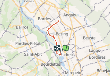
Rs Baudreix plus footing

mitch1952
Gebruiker

Lengte
9,9 km

Max. hoogte
244 m

Positief hoogteverschil
52 m
Km-Effort
10,6 km

Min. hoogte
225 m

Negatief hoogteverschil
51 m
Boucle
Ja
Datum van aanmaak :
2024-11-16 10:08:24.0
Laatste wijziging :
2024-11-17 15:08:29.04
1h17
Moeilijkheid : Onbekend

Gratisgps-wandelapplicatie
 SityTrail
IGN / Geografische instituten
SityTrail Plus
De wereld gaat voor u open
Over ons
Tocht Lopen van 9,9 km beschikbaar op Nieuw-Aquitanië, Pyrénées-Atlantiques, Baudreix. Deze tocht wordt voorgesteld door mitch1952.
Plaatsbepaling
Land:
France
Regio :
Nieuw-Aquitanië
Departement/Provincie :
Pyrénées-Atlantiques
Gemeente :
Baudreix
Locatie:
Unknown
Vertrek:(Dec)
Vertrek:(UTM)
722414 ; 4787180 (30T) N.
Opmerkingen