


mace intra muros

lousim22
Gebruiker
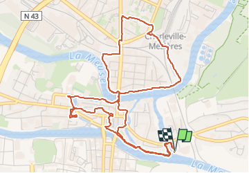

Lengte
6,5 km

Max. hoogte
158 m

Positief hoogteverschil
48 m
Km-Effort
7,1 km

Min. hoogte
141 m

Negatief hoogteverschil
49 m
Boucle
Ja
Datum van aanmaak :
2024-12-01 09:02:15.488
Laatste wijziging :
2024-12-01 10:33:22.597
1h30
Moeilijkheid : Gemakkelijk

Gratisgps-wandelapplicatie
 SityTrail
IGN / Geografische instituten
SityTrail Plus
De wereld gaat voor u open
Over ons
Tocht Stappen van 6,5 km beschikbaar op Grand Est, Ardennes, Charleville-Mézières. Deze tocht wordt voorgesteld door lousim22.
Plaatsbepaling
Land:
France
Regio :
Grand Est
Departement/Provincie :
Ardennes
Gemeente :
Charleville-Mézières
Locatie:
Unknown
Vertrek:(Dec)
Vertrek:(UTM)
624331 ; 5513139 (31U) N.
Opmerkingen