


11/12/2024 - Ouest Locronan, Nivet et Bois du Névet.Virtuel

babeth35
Gebruiker
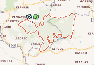

Lengte
12,1 km

Max. hoogte
152 m

Positief hoogteverschil
249 m
Km-Effort
15,4 km

Min. hoogte
33 m

Negatief hoogteverschil
254 m
Boucle
Ja
Datum van aanmaak :
2024-12-11 13:11:53.435
Laatste wijziging :
2024-12-11 13:26:46.495
3h29
Moeilijkheid : Gemakkelijk
3h29
Moeilijkheid : Moeilijk

Gratisgps-wandelapplicatie
 SityTrail
IGN / Geografische instituten
SityTrail Plus
De wereld gaat voor u open
Over ons
Tocht Te voet van 12,1 km beschikbaar op Bretagne, Finistère, Kerlaz. Deze tocht wordt voorgesteld door babeth35.
Plaatsbepaling
Land:
France
Regio :
Bretagne
Departement/Provincie :
Finistère
Gemeente :
Kerlaz
Locatie:
Unknown
Vertrek:(Dec)
Vertrek:(UTM)
406923 ; 5326639 (30U) N.
Opmerkingen