


sassay Gs 01 2025 10km

mimilolo
Gebruiker
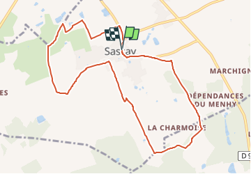

Lengte
10,3 km

Max. hoogte
123 m

Positief hoogteverschil
66 m
Km-Effort
11,2 km

Min. hoogte
106 m

Negatief hoogteverschil
66 m
Boucle
Ja
Datum van aanmaak :
2025-01-02 15:49:07.392
Laatste wijziging :
2025-01-02 15:50:03.532
2h32
Moeilijkheid : Gemakkelijk

Gratisgps-wandelapplicatie
 SityTrail
IGN / Geografische instituten
SityTrail Plus
De wereld gaat voor u open
Over ons
Tocht Te voet van 10,3 km beschikbaar op Centre-Val de Loire, Loir-et-Cher, Sassay. Deze tocht wordt voorgesteld door mimilolo.
Beschrijving
depart salle des fêtes
Plaatsbepaling
Land:
France
Regio :
Centre-Val de Loire
Departement/Provincie :
Loir-et-Cher
Gemeente :
Sassay
Locatie:
Unknown
Vertrek:(Dec)
Vertrek:(UTM)
382379 ; 5250110 (31T) N.
Opmerkingen