


Col de vence 06 4

papajp
Gebruiker
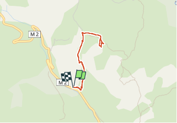

Lengte
3,3 km

Max. hoogte
732 m

Positief hoogteverschil
143 m
Km-Effort
5,2 km

Min. hoogte
584 m

Negatief hoogteverschil
147 m
Boucle
Ja
Datum van aanmaak :
2025-01-07 14:00:01.0
Laatste wijziging :
2025-01-07 15:45:13.006

Gratisgps-wandelapplicatie
 SityTrail
IGN / Geografische instituten
SityTrail Plus
De wereld gaat voor u open
Over ons
Tocht van 3,3 km beschikbaar op Provence-Alpes-Côte d'Azur, Alpes-Maritimes, Vence. Deze tocht wordt voorgesteld door papajp.
Plaatsbepaling
Land:
France
Regio :
Provence-Alpes-Côte d'Azur
Departement/Provincie :
Alpes-Maritimes
Gemeente :
Vence
Locatie:
Unknown
Vertrek:(Dec)
Vertrek:(UTM)
347047 ; 4845521 (32T) N.
Opmerkingen