![](/images/other/stat-length.png)
![Tocht Stappen Onbekend - Podragu > Lacul Baléa - Photo](https://media.geolcdn.com/t/1900/400/ext.pjpeg?maxdim=2&url=https%3A%2F%2Fstatic1.geolcdn.com%2Fsiteimages%2Fupload%2Ffiles%2F1553511878bg_sport_marche.png)
Podragu > Lacul Baléa
heb
Gebruiker
![Lengte](/images/other/stat-length.png)
Lengte
8,6 km
![Max. hoogte](https://static1.geolcdn.com/siteimages/upload/files/1508320355ic_sort_altitude_max_24dp.png)
Max. hoogte
2442 m
![Positief hoogteverschil](https://static1.geolcdn.com/siteimages/upload/files/1508320355ic_sort_den_pos_24dp.png)
Positief hoogteverschil
769 m
![Km-Effort](/images/other/stat-length.png)
Km-Effort
19,1 km
![Min. hoogte](https://static1.geolcdn.com/siteimages/upload/files/1508320355ic_sort_altitude_min_24dp.png)
Min. hoogte
2030 m
![Negatief hoogteverschil](https://static1.geolcdn.com/siteimages/upload/files/1508320355ic_sort_den_neg_24dp.png)
Negatief hoogteverschil
842 m
![Boucle](https://static1.geolcdn.com/siteimages/upload/files/16400158638029165_repeat_loop_refresh_sync_direction_icon.png)
Boucle
Neen
Datum van aanmaak :
2015-07-25 00:00:00.0
Laatste wijziging :
2015-07-25 00:00:00.0
![Stappen](https://static1.geolcdn.com/sitytour/trail-icons/101.png)
3h59
Moeilijkheid : Moeilijk
![Scan deze QR-code om de tocht te openen in de SityTrail-applicatie](https://capi.geolives.com/qq0zvz2zws4bq2lad0pu/sitytour/trails/431328/qr.png?size=200)
Gratisgps-wandelapplicatie
Over ons
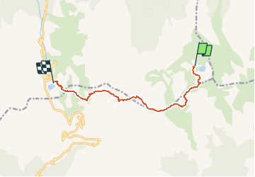
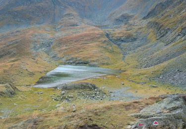
Tocht Stappen van 8,6 km beschikbaar op Brașov, Onbekend, Onbekend. Deze tocht wordt voorgesteld door heb.
Beschrijving
Cabana Podragu - ?aua Podragu (triang.rouge sur 1km) puis à droite :
(bande rouge sur 6.8 km)
Traseu Creasta - ?aua Podragului - ?aua Caprei puis tout droit balisage triangle bleu pendant 870 m avec passage difficle avec chaîne
Plaatsbepaling
Land:
Romania
Regio :
Brașov
Departement/Provincie :
Onbekend
Gemeente :
Onbekend
Locatie:
Ucea
Vertrek:(Dec)
Vertrek:(UTM)
319650 ; 5053337 (35T) N.
Opmerkingen
Wandeltochten in de omgeving
![Tocht Te voet Onbekend - L. Capra - Refugiul Bâlea - Tunel - Refugiul Călțun - Photo](https://media.geolcdn.com/t/375/260/ext.jpg?maxdim=2&url=https%3A%2F%2Fmedia.geolcdn.com%2Ff%2Fc2f1f927-6bbb-40bb-9c31-859ad439b022.jpeg)
![Te voet Te voet](https://static1.geolcdn.com/sitytour/trail-icons/100.png)
L. Capra - Refugiul Bâlea - Tunel - Refugiul Călțun
Te voet
Gemakkelijk
Onbekend,
Argeș,
Onbekend,
Romania
![](/images/other/stat-length.png)
7,1 km | 15,4 km-effort
3h 29min
![](https://static1.geolcdn.com/siteimages/upload/files/16400158638029165_repeat_loop_refresh_sync_direction_icon.png)
Neen
![Tocht Te voet Onbekend - Șaua dintre Lacuri - L. Podrăgel - Gura Podragului - Photo](https://media.geolcdn.com/t/375/260/ext.jpg?maxdim=2&url=https%3A%2F%2Fmedia.geolcdn.com%2Ff%2Fd7ab90bf-cd02-4843-9a23-544238a1c56a.jpeg)
![Te voet Te voet](https://static1.geolcdn.com/sitytour/trail-icons/100.png)
Șaua dintre Lacuri - L. Podrăgel - Gura Podragului
Te voet
Gemakkelijk
Onbekend,
Sibiu,
Onbekend,
Romania
![](/images/other/stat-length.png)
5,4 km | 9,1 km-effort
2h 3min
![](https://static1.geolcdn.com/siteimages/upload/files/16400158638029165_repeat_loop_refresh_sync_direction_icon.png)
Neen
![Tocht Te voet Onbekend - Fereastra Zmeilor - Șaua dintre Lacuri - Cabana Podragu - Photo](https://media.geolcdn.com/t/375/260/ext.jpg?maxdim=2&url=https%3A%2F%2Fmedia.geolcdn.com%2Ff%2Ff9cbdf51-eb2c-4f80-8656-1ed4b4620889.jpeg)
![Te voet Te voet](https://static1.geolcdn.com/sitytour/trail-icons/100.png)
Fereastra Zmeilor - Șaua dintre Lacuri - Cabana Podragu
Te voet
Gemakkelijk
Onbekend,
Argeș,
Onbekend,
Romania
![](/images/other/stat-length.png)
3,5 km | 9 km-effort
2h 2min
![](https://static1.geolcdn.com/siteimages/upload/files/16400158638029165_repeat_loop_refresh_sync_direction_icon.png)
Neen
![Tocht Te voet Onbekend - Nucșoara - V. Rea - Portița Viștei - Photo](https://media.geolcdn.com/t/375/260/ext.jpg?maxdim=2&url=https%3A%2F%2Fmedia.geolcdn.com%2Ff%2F18b41164-e23a-4dbb-b140-7af0fd07ee45.jpeg)
![Te voet Te voet](https://static1.geolcdn.com/sitytour/trail-icons/100.png)
Nucșoara - V. Rea - Portița Viștei
Te voet
Zeer moeilijk
Onbekend,
Argeș,
Onbekend,
Romania
![](/images/other/stat-length.png)
46 km | 59 km-effort
13h 30min
![](https://static1.geolcdn.com/siteimages/upload/files/16400158638029165_repeat_loop_refresh_sync_direction_icon.png)
Neen
![Tocht Te voet Onbekend - V. Buda - Curmătura Moldoveanului - Photo](https://media.geolcdn.com/t/375/260/ext.jpg?maxdim=2&url=https%3A%2F%2Fstatic1.geolcdn.com%2Fsiteimages%2Fupload%2Ffiles%2F1545311037marcheuse_200dpi.jpg)
![Te voet Te voet](https://static1.geolcdn.com/sitytour/trail-icons/100.png)
V. Buda - Curmătura Moldoveanului
Te voet
Gemakkelijk
Onbekend,
Argeș,
Onbekend,
Romania
![](/images/other/stat-length.png)
4,3 km | 13 km-effort
2h 56min
![](https://static1.geolcdn.com/siteimages/upload/files/16400158638029165_repeat_loop_refresh_sync_direction_icon.png)
Neen
![Tocht Te voet Onbekend - Izv. Podu Giurgiului - Șaua Orzănele - Photo](https://media.geolcdn.com/t/375/260/ext.jpg?maxdim=2&url=https%3A%2F%2Fstatic1.geolcdn.com%2Fsiteimages%2Fupload%2Ffiles%2F1545311037marcheuse_200dpi.jpg)
![Te voet Te voet](https://static1.geolcdn.com/sitytour/trail-icons/100.png)
Izv. Podu Giurgiului - Șaua Orzănele
Te voet
Gemakkelijk
Onbekend,
Argeș,
Onbekend,
Romania
![](/images/other/stat-length.png)
3,9 km | 12,4 km-effort
2h 48min
![](https://static1.geolcdn.com/siteimages/upload/files/16400158638029165_repeat_loop_refresh_sync_direction_icon.png)
Neen
![Tocht Stappen Onbekend - Vistea Mare > Podragu - Photo](https://media.geolcdn.com/t/375/260/ext.jpg?maxdim=2&url=https%3A%2F%2Fstatic1.geolcdn.com%2Fsiteimages%2Fupload%2Ffiles%2F1553511878bg_sport_marche.png)
![Stappen Stappen](https://static1.geolcdn.com/sitytour/trail-icons/101.png)
Vistea Mare > Podragu
Stappen
Medium
Onbekend,
Argeș,
Onbekend,
Romania
![](/images/other/stat-length.png)
7,6 km | 16,3 km-effort
7h 47min
![](https://static1.geolcdn.com/siteimages/upload/files/16400158638029165_repeat_loop_refresh_sync_direction_icon.png)
Neen