


RS Rontignon

mitch1952
Gebruiker
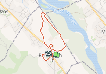

Lengte
3,9 km

Max. hoogte
203 m

Positief hoogteverschil
21 m
Km-Effort
4,2 km

Min. hoogte
191 m

Negatief hoogteverschil
20 m
Boucle
Ja
Datum van aanmaak :
2025-01-14 13:05:18.0
Laatste wijziging :
2025-01-14 14:47:58.344

Gratisgps-wandelapplicatie
 SityTrail
IGN / Geografische instituten
SityTrail Plus
De wereld gaat voor u open
Over ons
Tocht van 3,9 km beschikbaar op Nieuw-Aquitanië, Pyrénées-Atlantiques, Rontignon. Deze tocht wordt voorgesteld door mitch1952.
Plaatsbepaling
Land:
France
Regio :
Nieuw-Aquitanië
Departement/Provincie :
Pyrénées-Atlantiques
Gemeente :
Rontignon
Locatie:
Unknown
Vertrek:(Dec)
Vertrek:(UTM)
716759 ; 4793070 (30T) N.
Opmerkingen