


Le Plan sans boue fait 2025

pidjam
Gebruiker
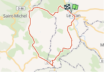

Lengte
9,8 km

Max. hoogte
367 m

Positief hoogteverschil
166 m
Km-Effort
12 km

Min. hoogte
258 m

Negatief hoogteverschil
167 m
Boucle
Ja
Datum van aanmaak :
2025-01-30 13:26:44.308
Laatste wijziging :
2025-01-30 15:52:16.817
2h08
Moeilijkheid : Gemakkelijk

Gratisgps-wandelapplicatie
 SityTrail
IGN / Geografische instituten
SityTrail Plus
De wereld gaat voor u open
Over ons
Tocht Stappen van 9,8 km beschikbaar op Occitanië, Haute-Garonne, Le Plan. Deze tocht wordt voorgesteld door pidjam.
Plaatsbepaling
Land:
France
Regio :
Occitanië
Departement/Provincie :
Haute-Garonne
Gemeente :
Le Plan
Locatie:
Unknown
Vertrek:(Dec)
Vertrek:(UTM)
347094 ; 4781198 (31T) N.
Opmerkingen