


![Tocht Te voet Dubí - [F] Dubský Cínovecký okruh - Photo](https://media.geolcdn.com/t/1900/400/c6545c9b-76f0-4a2c-85bc-e7700ca98aca.jpeg&format=pjpeg&maxdim=2)
[F] Dubský Cínovecký okruh

SityTrail - itinéraires balisés pédestres
Tous les sentiers balisés d’Europe GUIDE+

Lengte
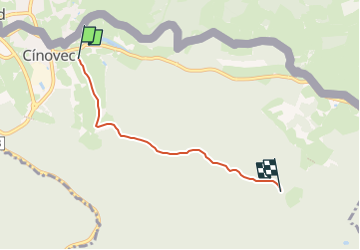
3,5 km

Max. hoogte
873 m

Positief hoogteverschil
51 m
Km-Effort
4,3 km

Min. hoogte
775 m

Negatief hoogteverschil
99 m
Boucle
Neen

Markering
Datum van aanmaak :
2025-02-07 05:48:26.172
Laatste wijziging :
2025-02-07 05:48:26.172
58m
Moeilijkheid : Gemakkelijk

Gratisgps-wandelapplicatie
 SityTrail
IGN / Geografische instituten
SityTrail Plus
De wereld gaat voor u open
Over ons
Tocht Te voet van 3,5 km beschikbaar op Noordwest, Ústecký kraj, Dubí. Deze tocht wordt voorgesteld door SityTrail - itinéraires balisés pédestres.
Beschrijving
Tocht aangemaakt door město Dubí.
Dubské vycházkové trasy
Foto's
![Tocht Te voet Dubí - [F] Dubský Cínovecký okruh - Photo 1](https://media.geolcdn.com/t/2048/auto/582d6075-5b6c-4e7d-8f01-616e0d7bd87c.jpeg&format=jpg&maxdim=0 "Tocht Te voet Dubí - [F] Dubský Cínovecký okruh - Photo 1")
![Tocht Te voet Dubí - [F] Dubský Cínovecký okruh - Photo 2](https://media.geolcdn.com/t/2048/auto/f250f21e-5bce-4d53-b3b8-bc5cc9eabbac.jpeg&format=jpg&maxdim=0 "Tocht Te voet Dubí - [F] Dubský Cínovecký okruh - Photo 2")
![Tocht Te voet Dubí - [F] Dubský Cínovecký okruh - Photo 3](https://media.geolcdn.com/t/2048/auto/8641a584-0f54-4105-84bc-bdfd616f8403.jpeg&format=jpg&maxdim=0 "Tocht Te voet Dubí - [F] Dubský Cínovecký okruh - Photo 3")
![Tocht Te voet Dubí - [F] Dubský Cínovecký okruh - Photo 4](https://media.geolcdn.com/t/2048/auto/c0746143-7b50-48fd-8f1a-e6bd88aa1443.jpeg&format=jpg&maxdim=0 "Tocht Te voet Dubí - [F] Dubský Cínovecký okruh - Photo 4")
![Tocht Te voet Dubí - [F] Dubský Cínovecký okruh - Photo 5](https://media.geolcdn.com/t/2048/auto/ff46e003-ad27-47f2-ac03-8948c2766fff.jpeg&format=jpg&maxdim=0 "Tocht Te voet Dubí - [F] Dubský Cínovecký okruh - Photo 5")
![Tocht Te voet Dubí - [F] Dubský Cínovecký okruh - Photo 6](https://media.geolcdn.com/t/2048/auto/d8384939-c032-4698-8c28-d3c6f7209f1f.jpeg&format=jpg&maxdim=0 "Tocht Te voet Dubí - [F] Dubský Cínovecký okruh - Photo 6")
![Tocht Te voet Dubí - [F] Dubský Cínovecký okruh - Photo 7](https://media.geolcdn.com/t/2048/auto/a02954f8-dd95-4471-81d2-71f258b38f7e.jpeg&format=jpg&maxdim=0 "Tocht Te voet Dubí - [F] Dubský Cínovecký okruh - Photo 7")
![Tocht Te voet Dubí - [F] Dubský Cínovecký okruh - Photo 8](https://media.geolcdn.com/t/2048/auto/419682f7-817a-464a-a1e8-02aaa6c3bc16.jpeg&format=jpg&maxdim=0 "Tocht Te voet Dubí - [F] Dubský Cínovecký okruh - Photo 8")
![Tocht Te voet Dubí - [F] Dubský Cínovecký okruh - Photo 9](https://media.geolcdn.com/t/2048/auto/c6545c9b-76f0-4a2c-85bc-e7700ca98aca.jpeg&format=jpg&maxdim=0 "Tocht Te voet Dubí - [F] Dubský Cínovecký okruh - Photo 9")
Plaatsbepaling
Land:
Czech Republic
Regio :
Noordwest
Departement/Provincie :
Ústecký kraj
Gemeente :
Dubí
Locatie:
Unknown
Vertrek:(Dec)
Vertrek:(UTM)
413452 ; 5620683 (33U) N.
Opmerkingen