


Lac de la lauch - Col de Hilsen

Alain28/01
Gebruiker
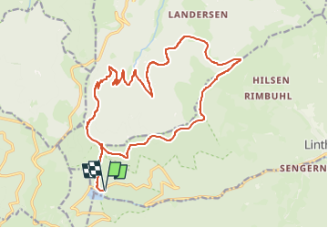

Lengte
20 km

Max. hoogte
1267 m

Positief hoogteverschil
953 m
Km-Effort
33 km

Min. hoogte
738 m

Negatief hoogteverschil
954 m
Boucle
Ja
Datum van aanmaak :
2025-02-17 16:19:56.954
Laatste wijziging :
2025-02-17 16:21:24.659
7h29
Moeilijkheid : Zeer moeilijk

Gratisgps-wandelapplicatie
 SityTrail
IGN / Geografische instituten
SityTrail Plus
De wereld gaat voor u open
Over ons
Tocht Stappen van 20 km beschikbaar op Grand Est, Haut-Rhin, Linthal. Deze tocht wordt voorgesteld door Alain28/01.
Plaatsbepaling
Land:
France
Regio :
Grand Est
Departement/Provincie :
Haut-Rhin
Gemeente :
Linthal
Locatie:
Unknown
Vertrek:(Dec)
Vertrek:(UTM)
354104 ; 5311093 (32T) N.
Opmerkingen