


Test jogging 5km

augustefranckart
Gebruiker
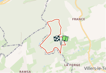

Lengte
5,1 km

Max. hoogte
240 m

Positief hoogteverschil
113 m
Km-Effort
6,6 km

Min. hoogte
149 m

Negatief hoogteverschil
115 m
Boucle
Ja
Datum van aanmaak :
2025-03-02 14:48:13.637
Laatste wijziging :
2025-03-02 15:57:05.047
0m
Moeilijkheid : Moeilijk

Gratisgps-wandelapplicatie
 SityTrail
IGN / Geografische instituten
SityTrail Plus
De wereld gaat voor u open
Over ons
Tocht Lopen van 5,1 km beschikbaar op Wallonië, Luik, Nandrin. Deze tocht wordt voorgesteld door augustefranckart.
Beschrijving
test pour le jogging des 5km de villers le temple
Plaatsbepaling
Land:
Belgium
Regio :
Wallonië
Departement/Provincie :
Luik
Gemeente :
Nandrin
Locatie:
Unknown
Vertrek:(Dec)
Vertrek:(UTM)
666436 ; 5598727 (31U) N.
Opmerkingen