


MBE 7 km chateau val par buisson richard

patb54
Gebruiker
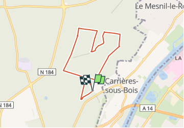

Lengte
6,7 km

Max. hoogte
86 m

Positief hoogteverschil
73 m
Km-Effort
7,7 km

Min. hoogte
62 m

Negatief hoogteverschil
72 m
Boucle
Ja
Datum van aanmaak :
2025-03-11 07:35:59.174
Laatste wijziging :
2025-03-11 07:40:51.135
1h44
Moeilijkheid : Medium

Gratisgps-wandelapplicatie
 SityTrail
IGN / Geografische instituten
SityTrail Plus
De wereld gaat voor u open
Over ons
Tocht Stappen van 6,7 km beschikbaar op Île-de-France, Yvelines, Saint-Germain-en-Laye. Deze tocht wordt voorgesteld door patb54.
Beschrijving
Parcours rando santé
Plaatsbepaling
Land:
France
Regio :
Île-de-France
Departement/Provincie :
Yvelines
Gemeente :
Saint-Germain-en-Laye
Locatie:
Saint-Germain-en-Laye
Vertrek:(Dec)
Vertrek:(UTM)
434481 ; 5419043 (31U) N.
Opmerkingen