


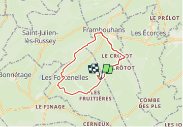
Rallye à la ferme Le puits du Glaçon, circuit 12 km

billodmorelpatrick
Gebruiker

Lengte
11,6 km

Max. hoogte
966 m

Positief hoogteverschil
221 m
Km-Effort
14,6 km

Min. hoogte
851 m

Negatief hoogteverschil
221 m
Boucle
Ja
Datum van aanmaak :
2025-03-13 14:10:32.715
Laatste wijziging :
2025-03-13 14:14:43.049
3h18
Moeilijkheid : Moeilijk

Gratisgps-wandelapplicatie
 SityTrail
IGN / Geografische instituten
SityTrail Plus
De wereld gaat voor u open
Over ons
Tocht Stappen van 11,6 km beschikbaar op Bourgondië-Franche-Comté, Doubs, Les Fontenelles. Deze tocht wordt voorgesteld door billodmorelpatrick.
Beschrijving
Le puits du Glaçon, Frambouhans, crêtes piont de vue sur les Alpes Bernoise, chapelle St Anne, lavogne.

Plaatsbepaling
Land:
France
Regio :
Bourgondië-Franche-Comté
Departement/Provincie :
Doubs
Gemeente :
Les Fontenelles
Locatie:
Unknown
Vertrek:(Dec)
Vertrek:(UTM)
330676 ; 5229460 (32T) N.
Opmerkingen