


visorando-st-laurent-d-oingt-ste-paule

hearly
Gebruiker
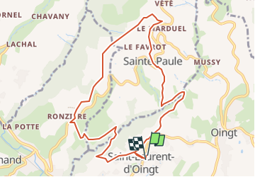

Lengte
10,3 km

Max. hoogte
564 m

Positief hoogteverschil
370 m
Km-Effort
15,3 km

Min. hoogte
322 m

Negatief hoogteverschil
366 m
Boucle
Ja
Datum van aanmaak :
2025-03-17 09:06:00.0
Laatste wijziging :
2025-03-17 09:06:18.787

Gratisgps-wandelapplicatie
 SityTrail
IGN / Geografische instituten
SityTrail Plus
De wereld gaat voor u open
Over ons
Tocht van 10,3 km beschikbaar op Auvergne-Rhône-Alpes, Rhône, Val d'Oingt. Deze tocht wordt voorgesteld door hearly.
Plaatsbepaling
Land:
France
Regio :
Auvergne-Rhône-Alpes
Departement/Provincie :
Rhône
Gemeente :
Val d'Oingt
Locatie:
Saint-Laurent-d'Oingt
Vertrek:(Dec)
Vertrek:(UTM)
621240 ; 5089126 (31T) N.
Opmerkingen