


circuit rouge numéro 7

xst
Gebruiker
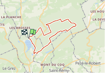

Lengte
14 km

Max. hoogte
280 m

Positief hoogteverschil
214 m
Km-Effort
16,9 km

Min. hoogte
204 m

Negatief hoogteverschil
219 m
Boucle
Ja
Datum van aanmaak :
2025-03-17 13:18:48.739
Laatste wijziging :
2025-03-17 14:57:07.597
1h36
Moeilijkheid : Medium

Gratisgps-wandelapplicatie
 SityTrail
IGN / Geografische instituten
SityTrail Plus
De wereld gaat voor u open
Over ons
Tocht Mountainbike van 14 km beschikbaar op Pays de la Loire, Sarthe, Sillé-le-Guillaume. Deze tocht wordt voorgesteld door xst.
Plaatsbepaling
Land:
France
Regio :
Pays de la Loire
Departement/Provincie :
Sarthe
Gemeente :
Sillé-le-Guillaume
Locatie:
Unknown
Vertrek:(Dec)
Vertrek:(UTM)
713275 ; 5344010 (30U) N.
Opmerkingen