


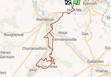
Hanches Jouie

topophil
Gebruiker

Lengte
38 km

Max. hoogte
156 m

Positief hoogteverschil
452 m
Km-Effort
44 km

Min. hoogte
100 m

Negatief hoogteverschil
451 m
Boucle
Ja
Datum van aanmaak :
2025-03-20 12:38:43.5
Laatste wijziging :
2025-03-20 15:42:20.494
3h03
Moeilijkheid : Zeer moeilijk

Gratisgps-wandelapplicatie
 SityTrail
IGN / Geografische instituten
SityTrail Plus
De wereld gaat voor u open
Over ons
Tocht Mountainbike van 38 km beschikbaar op Centre-Val de Loire, Eure-et-Loir, Hanches. Deze tocht wordt voorgesteld door topophil.
Plaatsbepaling
Land:
France
Regio :
Centre-Val de Loire
Departement/Provincie :
Eure-et-Loir
Gemeente :
Hanches
Locatie:
Unknown
Vertrek:(Dec)
Vertrek:(UTM)
399592 ; 5384158 (31U) N.
Opmerkingen