


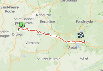
La croix Orcival Aurière Aydat Rouillas bas Le Moulassat

Pierre Dabin
Gebruiker

Lengte
16,2 km

Max. hoogte
999 m

Positief hoogteverschil
295 m
Km-Effort
21 km

Min. hoogte
815 m

Negatief hoogteverschil
407 m
Boucle
Neen
Datum van aanmaak :
2025-03-23 14:05:56.284
Laatste wijziging :
2025-03-23 14:10:13.057
2h42
Moeilijkheid : Medium

Gratisgps-wandelapplicatie
 SityTrail
IGN / Geografische instituten
SityTrail Plus
De wereld gaat voor u open
Over ons
Tocht Paardrijden van 16,2 km beschikbaar op Auvergne-Rhône-Alpes, Puy-de-Dôme, Orcival. Deze tocht wordt voorgesteld door Pierre Dabin.
Plaatsbepaling
Land:
France
Regio :
Auvergne-Rhône-Alpes
Departement/Provincie :
Puy-de-Dôme
Gemeente :
Orcival
Locatie:
Unknown
Vertrek:(Dec)
Vertrek:(UTM)
487940 ; 5059400 (31T) N.
Opmerkingen