


rando odeigne 1-04-2025

japy54
Gebruiker GUIDE
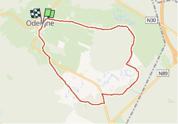

Lengte
8,3 km

Max. hoogte
650 m

Positief hoogteverschil
158 m
Km-Effort
10,4 km

Min. hoogte
527 m

Negatief hoogteverschil
156 m
Boucle
Ja
Datum van aanmaak :
2025-04-01 07:16:43.969
Laatste wijziging :
2025-04-01 10:28:59.432
2h28
Moeilijkheid : Gemakkelijk

Gratisgps-wandelapplicatie
 SityTrail
IGN / Geografische instituten
SityTrail Plus
De wereld gaat voor u open
Over ons
Tocht Stappen van 8,3 km beschikbaar op Wallonië, Luxemburg, Manhay. Deze tocht wordt voorgesteld door japy54.
Foto's


Plaatsbepaling
Land:
Belgium
Regio :
Wallonië
Departement/Provincie :
Luxemburg
Gemeente :
Manhay
Locatie:
Unknown
Vertrek:(Dec)
Vertrek:(UTM)
691283 ; 5570537 (31U) N.
Opmerkingen