


minerve_ai27xla

yt34
Gebruiker
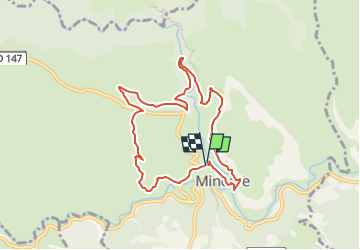

Lengte
8,9 km

Max. hoogte
354 m

Positief hoogteverschil
355 m
Km-Effort
13,6 km

Min. hoogte
161 m

Negatief hoogteverschil
358 m
Boucle
Ja
Datum van aanmaak :
2025-04-02 09:27:06.785
Laatste wijziging :
2025-04-02 09:30:22.057
3h05
Moeilijkheid : Moeilijk

Gratisgps-wandelapplicatie
 SityTrail
IGN / Geografische instituten
SityTrail Plus
De wereld gaat voor u open
Over ons
Tocht Stappen van 8,9 km beschikbaar op Occitanië, Hérault, Minerve. Deze tocht wordt voorgesteld door yt34.


Plaatsbepaling
Land:
France
Regio :
Occitanië
Departement/Provincie :
Hérault
Gemeente :
Minerve
Locatie:
Unknown
Vertrek:(Dec)
Vertrek:(UTM)
479211 ; 4800377 (31T) N.
Opmerkingen