


tt

chuck
Gebruiker
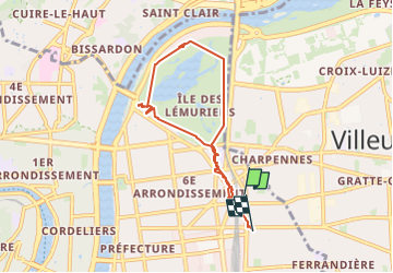

Lengte
6,7 km

Max. hoogte
184 m

Positief hoogteverschil
66 m
Km-Effort
7,5 km

Min. hoogte
166 m

Negatief hoogteverschil
65 m
Boucle
Neen
Datum van aanmaak :
2025-04-05 06:51:47.943
Laatste wijziging :
2025-04-05 07:32:49.052
40m
Moeilijkheid : Heel gemakkelijk

Gratisgps-wandelapplicatie
 SityTrail
IGN / Geografische instituten
SityTrail Plus
De wereld gaat voor u open
Over ons
Tocht Trail van 6,7 km beschikbaar op Auvergne-Rhône-Alpes, Métropole de Lyon, Lyon. Deze tocht wordt voorgesteld door chuck.
Plaatsbepaling
Land:
France
Regio :
Auvergne-Rhône-Alpes
Departement/Provincie :
Métropole de Lyon
Gemeente :
Lyon
Locatie:
Lyon 6e Arrondissement
Vertrek:(Dec)
Vertrek:(UTM)
644726 ; 5069761 (31T) N.
Opmerkingen