
Compostelle 08 - Espalion -> Estaing

uru2010
Gebruiker
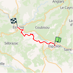

Lengte
13,8 km

Max. hoogte
491 m

Positief hoogteverschil
303 m
Km-Effort
17,9 km

Min. hoogte
312 m

Negatief hoogteverschil
327 m
Boucle
Neen
Datum van aanmaak :
2018-06-12 00:00:00.0
Laatste wijziging :
2018-06-12 00:00:00.0
3h53
Moeilijkheid : Gemakkelijk

Gratisgps-wandelapplicatie
 SityTrail
IGN / Geografische instituten
SityTrail Plus
De wereld gaat voor u open
Over ons
Tocht Stappen van 13,8 km beschikbaar op Occitanië, Aveyron, Espalion. Deze tocht wordt voorgesteld door uru2010.
Beschrijving
Chemin de St Jacques de Compostelle
Espalion -> Estaing
Foto's

Plaatsbepaling
Land:
France
Regio :
Occitanië
Departement/Provincie :
Aveyron
Gemeente :
Espalion
Locatie:
Unknown
Vertrek:(Dec)
Vertrek:(UTM)
480951 ; 4929780 (31T) N.
Opmerkingen