


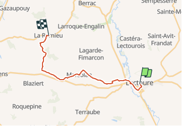
Compostelle 22 - Lectoure -> La Romieu

uru2010
Gebruiker

Lengte
19,8 km

Max. hoogte
219 m

Positief hoogteverschil
364 m
Km-Effort
25 km

Min. hoogte
75 m

Negatief hoogteverschil
359 m
Boucle
Neen
Datum van aanmaak :
2018-06-12 00:00:00.0
Laatste wijziging :
2018-06-12 00:00:00.0
5h26
Moeilijkheid : Gemakkelijk

Gratisgps-wandelapplicatie
 SityTrail
IGN / Geografische instituten
SityTrail Plus
De wereld gaat voor u open
Over ons
Tocht Stappen van 19,8 km beschikbaar op Occitanië, Gers, Lectoure. Deze tocht wordt voorgesteld door uru2010.
Beschrijving
Chemin de St Jacques de Compostelle
Lectoure - La Romieu
Plaatsbepaling
Land:
France
Regio :
Occitanië
Departement/Provincie :
Gers
Gemeente :
Lectoure
Locatie:
Unknown
Vertrek:(Dec)
Vertrek:(UTM)
309130 ; 4867295 (31T) N.
Opmerkingen