


Bira fouché Pyrénées champs vert

sameja
Gebruiker

Lengte
10,5 km

Max. hoogte
115 m

Positief hoogteverschil
211 m
Km-Effort
13,3 km

Min. hoogte
0 m

Negatief hoogteverschil
210 m
Boucle
Ja
Datum van aanmaak :
2025-04-15 09:19:18.0
Laatste wijziging :
2025-04-15 13:21:09.782
1h21
Moeilijkheid : Medium

Gratisgps-wandelapplicatie
 SityTrail
IGN / Geografische instituten
SityTrail Plus
De wereld gaat voor u open
Over ons
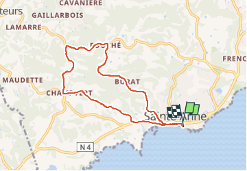
Tocht Trail van 10,5 km beschikbaar op Guadeloupe, Onbekend, Sainte-Anne. Deze tocht wordt voorgesteld door sameja.
Beschrijving
La boucle de st Anne
Plaatsbepaling
Land:
France
Regio :
Guadeloupe
Departement/Provincie :
Onbekend
Gemeente :
Sainte-Anne
Locatie:
Unknown
Vertrek:(Dec)
Vertrek:(UTM)
672714 ; 1794372 (20Q) N.
Opmerkingen