


Fontainebleau

Mom Viviane
Gebruiker

Lengte
3,4 km

Max. hoogte
86 m

Positief hoogteverschil
31 m
Km-Effort
3,8 km

Min. hoogte
66 m

Negatief hoogteverschil
29 m
Boucle
Neen
Datum van aanmaak :
2025-04-17 12:57:36.0
Laatste wijziging :
2025-04-17 14:38:11.31
1h29
Moeilijkheid : Gemakkelijk

Gratisgps-wandelapplicatie
 SityTrail
IGN / Geografische instituten
SityTrail Plus
De wereld gaat voor u open
Over ons
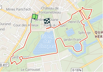
Tocht Stappen van 3,4 km beschikbaar op Île-de-France, Seine-et-Marne, Fontainebleau. Deze tocht wordt voorgesteld door Mom Viviane.
Plaatsbepaling
Land:
France
Regio :
Île-de-France
Departement/Provincie :
Seine-et-Marne
Gemeente :
Fontainebleau
Locatie:
Unknown
Vertrek:(Dec)
Vertrek:(UTM)
477602 ; 5361046 (31U) N.
Opmerkingen