


CANYON G

nordan
Gebruiker
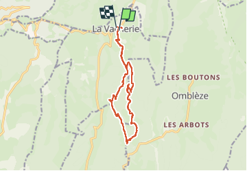

Lengte
14,3 km

Max. hoogte
1015 m

Positief hoogteverschil
554 m
Km-Effort
22 km

Min. hoogte
642 m

Negatief hoogteverschil
551 m
Boucle
Ja
Datum van aanmaak :
2025-05-03 08:00:45.701
Laatste wijziging :
2025-05-03 13:29:27.629
3h47
Moeilijkheid : Medium

Gratisgps-wandelapplicatie
 SityTrail
IGN / Geografische instituten
SityTrail Plus
De wereld gaat voor u open
Over ons
Tocht Stappen van 14,3 km beschikbaar op Auvergne-Rhône-Alpes, Drôme, Le Chaffal. Deze tocht wordt voorgesteld door nordan.
Plaatsbepaling
Land:
France
Regio :
Auvergne-Rhône-Alpes
Departement/Provincie :
Drôme
Gemeente :
Le Chaffal
Locatie:
Unknown
Vertrek:(Dec)
Vertrek:(UTM)
672509 ; 4972678 (31T) N.
Opmerkingen
galère avec le chien mais contournable. bien