


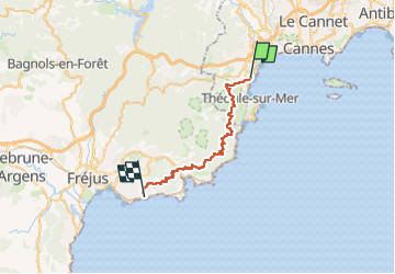
SityTrail - Traversée de l'Estérel Mandelieu - Boulouris

GeorgesV.
Gebruiker

Lengte
31 km

Max. hoogte
429 m

Positief hoogteverschil
1174 m
Km-Effort
47 km

Min. hoogte
4 m

Negatief hoogteverschil
1169 m
Boucle
Neen
Datum van aanmaak :
2025-05-03 22:04:45.987
Laatste wijziging :
2025-05-03 22:46:47.081

Gratisgps-wandelapplicatie
 SityTrail
IGN / Geografische instituten
SityTrail Plus
De wereld gaat voor u open
Over ons
Tocht van 31 km beschikbaar op Provence-Alpes-Côte d'Azur, Alpes-Maritimes, Mandelieu-la-Napoule. Deze tocht wordt voorgesteld door GeorgesV..
Plaatsbepaling
Land:
France
Regio :
Provence-Alpes-Côte d'Azur
Departement/Provincie :
Alpes-Maritimes
Gemeente :
Mandelieu-la-Napoule
Locatie:
Unknown
Vertrek:(Dec)
Vertrek:(UTM)
333668 ; 4821123 (32T) N.
Opmerkingen