


sortie vtt du 14072015 n7 pierre percee

fabwin
Gebruiker GUIDE
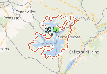

Lengte
25 km

Max. hoogte
491 m

Positief hoogteverschil
589 m
Km-Effort
33 km

Min. hoogte
374 m

Negatief hoogteverschil
588 m
Boucle
Ja
Datum van aanmaak :
2015-07-14 00:00:00.0
Laatste wijziging :
2015-07-14 00:00:00.0
2h38
Moeilijkheid : Onbekend

Gratisgps-wandelapplicatie
 SityTrail
IGN / Geografische instituten
SityTrail Plus
De wereld gaat voor u open
Over ons
Tocht Mountainbike van 25 km beschikbaar op Grand Est, Meurthe-et-Moselle, Badonviller. Deze tocht wordt voorgesteld door fabwin.
Plaatsbepaling
Land:
France
Regio :
Grand Est
Departement/Provincie :
Meurthe-et-Moselle
Gemeente :
Badonviller
Locatie:
Unknown
Vertrek:(Dec)
Vertrek:(UTM)
345769 ; 5370561 (32U) N.
Opmerkingen