
TERMES 48 - petit circuit

jeff66
Gebruiker
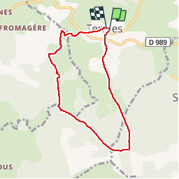

Lengte
7,3 km

Max. hoogte
1216 m

Positief hoogteverschil
119 m
Km-Effort
8,8 km

Min. hoogte
1120 m

Negatief hoogteverschil
120 m
Boucle
Ja
Datum van aanmaak :
2015-07-17 00:00:00.0
Laatste wijziging :
2015-07-17 00:00:00.0
1h46
Moeilijkheid : Gemakkelijk

Gratisgps-wandelapplicatie
 SityTrail
IGN / Geografische instituten
SityTrail Plus
De wereld gaat voor u open
Over ons
Tocht Stappen van 7,3 km beschikbaar op Occitanië, Lozère, Termes. Deze tocht wordt voorgesteld door jeff66.
Beschrijving
TERMES 48 - pont du renard - Las Barros - GR de pays du tour des monts d'aubrac - bois de Lachant - plos de Bouos - la Giroune - Lachant - le Mazuc de Vassal
Foto's


Plaatsbepaling
Land:
France
Regio :
Occitanië
Departement/Provincie :
Lozère
Gemeente :
Termes
Locatie:
Unknown
Vertrek:(Dec)
Vertrek:(UTM)
513283 ; 4962182 (31T) N.
Opmerkingen