


Rando Centuri

Fab-Oz
Gebruiker

Lengte
24 km

Max. hoogte
395 m

Positief hoogteverschil
983 m
Km-Effort
37 km

Min. hoogte
0 m

Negatief hoogteverschil
983 m
Boucle
Ja
Datum van aanmaak :
2025-05-20 07:48:32.428
Laatste wijziging :
2025-05-20 15:30:47.29
6h54
Moeilijkheid : Moeilijk

Gratisgps-wandelapplicatie
 SityTrail
IGN / Geografische instituten
SityTrail Plus
De wereld gaat voor u open
Over ons
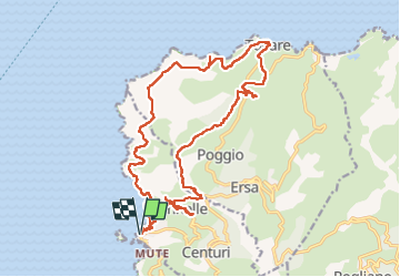
Tocht Stappen van 24 km beschikbaar op Corsica, Haute-Corse, Centuri. Deze tocht wordt voorgesteld door Fab-Oz.
Beschrijving
Départ du port de Centuri
Montée sur le hameau de Cannelle (très joli) puis au moulin de Mattei
Puis continuer jusqu'à Tollare
et retour pour le Sentier des Douaniers
Plaatsbepaling
Land:
France
Regio :
Corsica
Departement/Provincie :
Haute-Corse
Gemeente :
Centuri
Locatie:
Unknown
Vertrek:(Dec)
Vertrek:(UTM)
528366 ; 4756944 (32T) N.
Opmerkingen