


Bougés cerf

asclier0
Gebruiker
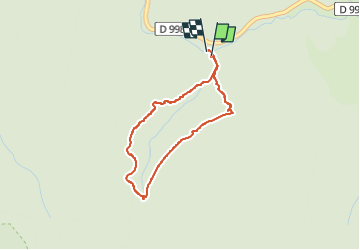

Lengte
3,2 km

Max. hoogte
1140 m

Positief hoogteverschil
89 m
Km-Effort
4,4 km

Min. hoogte
1047 m

Negatief hoogteverschil
93 m
Boucle
Ja
Datum van aanmaak :
2025-05-29 08:02:52.0
Laatste wijziging :
2025-05-29 09:31:21.4
1h08
Moeilijkheid : Gemakkelijk

Gratisgps-wandelapplicatie
 SityTrail
IGN / Geografische instituten
SityTrail Plus
De wereld gaat voor u open
Over ons
Tocht Stappen van 3,2 km beschikbaar op Occitanië, Lozère, Pont de Montvert - Sud Mont Lozère. Deze tocht wordt voorgesteld door asclier0.
Beschrijving
La fois où on a vu le cerf
Plaatsbepaling
Land:
France
Regio :
Occitanië
Departement/Provincie :
Lozère
Gemeente :
Pont de Montvert - Sud Mont Lozère
Locatie:
Saint-Maurice-de-Ventalon
Vertrek:(Dec)
Vertrek:(UTM)
563909 ; 4908968 (31T) N.
Opmerkingen