


Ecottes (Licques)

tenace
Gebruiker
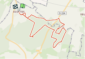

Lengte
11,3 km

Max. hoogte
172 m

Positief hoogteverschil
253 m
Km-Effort
14,6 km

Min. hoogte
79 m

Negatief hoogteverschil
250 m
Boucle
Ja
Datum van aanmaak :
2025-05-29 12:51:24.236
Laatste wijziging :
2025-05-29 16:51:30.138
3h59
Moeilijkheid : Moeilijk

Gratisgps-wandelapplicatie
 SityTrail
IGN / Geografische instituten
SityTrail Plus
De wereld gaat voor u open
Over ons
Tocht Stappen van 11,3 km beschikbaar op Hauts-de-France, Pas-de-Calais, Licques. Deze tocht wordt voorgesteld door tenace.
Plaatsbepaling
Land:
France
Regio :
Hauts-de-France
Departement/Provincie :
Pas-de-Calais
Gemeente :
Licques
Locatie:
Unknown
Vertrek:(Dec)
Vertrek:(UTM)
424651 ; 5630036 (31U) N.
Opmerkingen